Canada Wall Maps / USA Wall Maps / North America Wall Maps
- To place your order or for more information or questions on any of our products and services please contact us
- Pay by eTransfer or credit card over the phone (Visa, MC, or AM-EX). Pick-up or delivery, regular or rush shipping available
- Canada orders: Applicable taxes are extra. USA orders: No added taxes, but duty/brokerage fee (if any) may be added by the courier
Digital Projections has a Beautiful collection of Canada, USA, North America, and The Americas Wall Maps in stock. Large selection of World Wall Maps also in stock. Choice of Paper (flat/rolled), Hot Laminated,
or any of the various finishing options such as Mounted on Foam Core, Plaque Mounted, Float, or Flush Mounted, Picture Framed (Wood, Metal, Polystyrene), or Canvas Transfer.
Click on some images below to get a larger view.
Contact us now to place your order, confirm pricing/availability, and for more details. Phone, txt, or Email
Canada Wall Maps:
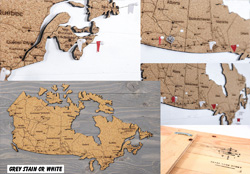 |
Canada Travel Map - Cork Pin Map with FlagsShare your travel story. Pin where you've been and add photos of your favorite places. This map of Canada is printed on eco-friendly cork. Comes
with a durable wood backing that is perfect for displaying in the home or office. Comes with 10 white flags to get you started. A portion of the proceeds is donated to the World Wildlife Fund.
24 x 14 inches. Mounted Flat. 2 Options:
Grey Background $149.00cdn
White Background $149.00cdn
|
 |
National Geographic Canada Political Wall MapA very detailed wall map of Canada, features the classic National Geographic reference styling. Features thousands of place names, accurate political boundaries, national parks,
archeological sites, and major infrastructure networks such as roads, canals, ferry routes, and railroads. Canada's diverse terrain is detailed through accurate shaded relief, coastal bathymetry, and symbolism for water features and
other landforms. This wall map depicts Canada and the areas surrounding the Great Lakes. Includes Canadian provinces and US State boundaries.
38 x 32 inches. Flat.
Paper $24.75cdn, Hot Laminated add $18.20cdn
Plaque Mounted? See Framing options and pricing for 70 UI
|
 |
National Geographic Canada Executive Wall MapA very detailed wall map of Canada, features the classic National Geographic reference styling. Features thousands of place names, accurate political boundaries, national parks,
archeological sites, and major infrastructure networks such as roads, canals, ferry routes, and railroads. Canada's diverse terrain is detailed through accurate shaded relief, coastal bathymetry, and symbolism for water features and
other landforms. This wall map depicts Canada and the areas surrounding the Great Lakes. Includes Canadian provinces and US State boundaries.
38 x 32 inches. Flat.
Paper $24.75cdn, Hot Laminated add $18.20cdn
Plaque Mounted? See Framing options and pricing for 70 UI
|
 |
Canada Political Natural Resources Canada Wall MapBeautiful wall map of Canada with relief shadowing with color coded provinces. Major cities, towns, bodies of water and major physical features are listed. Major road ways
are listed but not named. Scale 1:6,000,000.
43 x 36 inches. Flat.
Paper $24.85cdn
Hot Laminated add $20.50cdn
Plaque Mounted? See Framing options and pricing for 80 UI
|
 |
Canada Political Natural Resources Canada Wall Map - XLThis is a very clear and colorful political wall map of Canada. Features highlighted roadways and relief shading for a nice sense of depth. Shipped rolled. Scale
1:4,000,000.
63 x 46 inches. Flat.
Paper $39.75cdn
Hot Laminated add $36.10cdn
Plaque Mounted? See Framing options and pricing for 110 UI
|
 |
Relief Map of Canada Natural Resources Canada Wall MapA nice physical shaded relief map of Canada in Vertical Near Side Perspective Projection. Physiographic regions, Drainage Basins and Vegetation Cover are all shown in insets.
Scale 1:6,000,000.
43 x 36 inches. Flat.
Paper $24.85cdn
Hot Laminated $20.50cdn
Plaque Mounted? See Framing options and pricing for 80 UI
|
USA Wall Maps:
 |
National Geographic - USA Political Wall MapThis is a very nice wall map of the United States showing coloured borders between states, detailed roads, and cities. Flat.
43 x 30 inches: Paper $22.35cdn, Hot Laminated add $17.10cdn
Plaque Mounted? See Framing options and pricing for 74 UI
70 x 49 inches: Paper $49.75cdn, Hot Laminated add $40.10cdn
Plaque Mounted? See Framing options and pricing for 120 UI
110 x 76 inches, 3 Sheet Mural: Paper $178.95cdn, Hot Laminated add $159.60cdn
Plaque Mounted? See Framing options and contact us for pricing.
|
 |
National Geographic - USA Wall Map ExecutiveThis is an excellent wall map of the United States showing cities, roadways, parks, highlighted state borders and a very nice antique colour with current cartography. Flat.
43 x 30 inches: Paper $22.35cdn, Hot Laminated add $17.10cdn
Plaque Mounted? See Framing options and pricing for 74 UI
70 x 49 inches: Paper $31.75cdn, Hot Laminated add $40.10cdn
Plaque Mounted? See Framing options and pricing for 120 UI
|
North America Wall Maps:
 |
National Geographic - North America Political Wall MapShows the political boundaries of North America. Beautiful colour and detail. Insets of Alaska and Russia are included, along with Central America and the Caribbean. Flat.
24 x 30 inches: Paper $19.75cdn, Hot Laminated add $13.60cdn
Plaque Mounted? See Framing options and pricing for 54 UI
36 x 47 inches: Paper $34.75cdn, Hot Laminated add $20.50cdn
Plaque Mounted? See Framing options and pricing for 84 UI
|
 |
National Geographic - North America Executive Wall MapOur executive style political map of North America features country boundaries, place names, bodies of water, airports, major highways and roads, and much more. Scale
1:14,009,000.
24 x 30 inches: Paper $22.75cdn, Hot Laminated add $13.60cdn
Plaque Mounted? See Framing options and pricing for 54 UI
|
 |
North America Wall Map by Resources CanadaIncludes Central America and the Caribbean, with insets of Hawaii and Physiology. A Zenithal Equal Area projection.
35 x 39 inches.
Flat.
Paper $24.75cdn
Hot Laminated add $20.00cdn
Plaque Mounted? See Framing options and pricing for 74 UI
|
 |
Craenen - North America Wall Map with FlagsThis is a colourful wall map of North America. Countries are indicated by colour. State and provincial borders are shown. Relief shading. Includes inset maps of the Caribbean, Alaska
and Hawaii.
40 x 47 inches. Flat.
Paper $24.75cdn
Hot Laminated add $22.80cdn
Plaque Mounted? See Framing options and pricing for 88 UI
|
The Americas:
 |
National Geographic - The Americas Political Wall MapA beautifully rendered political map of North and South America. Accurately shows country, state, and province boundaries, place names, bodies of water, major highways
and roads, airports, and other geographic details. An inset map shows the physical geography of both continents.
24 x 37 inches. Flat.
Paper $19.75cdn
Hot Laminated add $13.70cdn
Plaque Mounted? See Framing options and pricing for 62 UI
|
For World Wall Maps, see our WORLD WALL MAPS page.
Order by Calling /
Texting us at (403) 547-0404
Or by sending us an Email to info@digitalpro.ca
|
|
|